
Step Forward:
People First Delhi
Location
New Delhi, India
Year
2024-2025
Category
Public Realm Development (Research - Design)
Project Type
Academics,
Urbanism Thesis
Project Classification
Research + Design
Guide
Mason White

New Delhi
Population: 34.6 Million
Climate: Sub-Tropical


Let’s understand Delhi’s Pollution


Dust makes up 20–50% of Delhi's PM₂.₅, with residential burning at 10–30%, vehicles, industries, and dust storms each at 10–20%, and power plants, farm fires, and fireworks contributing 5–10% each.
Early White Paper estimates and later CPCB models both confirm these shares.
Since when has it been happening in Delhi?
Challenges: Severe air pollution (PM2.5 > 15xWHO limit), heavy traffic (10Mvehicles), water scarcity (380Mgallon deficit)
Health: 30% rise in respiratory illnesses, 22% of adults overweight

Timeline of Breathability in New Delhi
Delhi's Pollution Timeline
This timeline maps Delhi’s ongoing battle with air pollution, tracing key shifts from unchecked industrial growth and rising vehicle use to policy responses like CNG adoption, GRAP, and Odd-Even. Despite repeated interventions, PM2.5 levels remain dangerously high, especially in winter, showing how reactive measures alone can’t solve a structural urban issue. It underscores the need for deeper, design-led change in how we move, build, and breathe in the city.

Current talk in Delhi on Pedestrianization
 |  |  |  |  |
|---|
What’s the urgency?
Delhi’s vigorous pedestrianization tackles unhealthy and invisible urbanism marked by traffic chaos, high fatality rates, andpoor air quality by reclaiming public spaces for a healthier, more inclusive city.

Urban Mobility & Congestion

Pedestrian Safety

Reclaiming Public Space

Air Pollution
Challenges Delhi faces about Pedestrianization
1.
2.
Entrenched Vehicular Dominance
Delhi’s car-centric road design makes it challenging to establish exclusive pedestrian spaces
Encroachment and Infrastructure Gaps
Street vendors and poor sidewalk maintenance frequently obstruct designated pedestrian areas.
3.
4.
Enforcement and Compliance Issues
Inconsistent enforcement and weak penalties allow unauthorized vehicle use in pedestrian zones
Lack of integration with Public Transit and Urban Design
Fragmented urban planning and inadequate last-mile connectivity hinder seamless pedestrian transit.


Polluted – Transit Zones of Delhi
This map shows how Delhi’s transit hubs are designed for mobility yet have become hotspots of poor air quality. The red halos where metro lines meet smog urge us to see these spaces not just as transfer points but as chances for transformation, with cleaner air, greener edges, and people-first design.
N
Legends

Metro Line
Transit Switching Point
Poor AQI Area
Polluted + Poor Infrastructure Intersection Diagram
A Vision for New Delhi: Streets for People, Air You Can Breathe
This action plan reimagines New Delhi as a city built around people—not cars. By prioritizing pedestrian-friendly streets and creating inviting public spaces or “urban rooms,” it aims to bring everyday life back to the city’s core.

Together, these shifts lay the foundation for a healthier, more walkable, and livable New Delhi.
The Action Plan

This action plan for Delhi focuses on transforming the city into a more pedestrian-friendly, livable environment. It begins by reducing car dependency and reimagining the public realm. The strategy emphasizes:
Together, these actions work toward the creation of Urban Rooms—welcoming, walkable public spaces that foster social interaction, promote sustainable mobility, and make Delhi a healthier, more inclusive city.
The Plantation Action Plan (PAP)


Kosam -Schleichera Oleosa
Amaltas -Cassia Fistula
Bistendu -Diospyros Cordifolia
Desi Babool - Acacia Nilotica
Mangifera indica -Mango Tree
1 year
Longer to grow
50 years
Interestingly, trees like mango, shisham and amaltas, which are popular across North India, were overlooked possibly because Delhi’s native trees are deciduous, which shed and look bare during the dry season. Regardless, some indigenous tree species were likely added later.

N
Scenarios in New Delhi
This map spotlights two pollution hotspots, Connaught Place and Anand Vihar, where industry, crop burning, and traffic collide. It calls on urban designers to reimagine transit hubs with cleaner mobility, green buffers, and resilient planning.
AQI -Air Quality Index
PM2.5 - 2.5 micrometres Particulate Matter
PM10 - 10 micrometres Particulate Matter
O3 - Ozone
NO2 –Nitrogen Dioxide
Study Focus Area
Study Area
Pollution Spread
Sites Periphery Diagram
Addressing site with variability
Connaught Place

Category - I
+ Transit Switching Points
- Colonial
- Formal
- Horizontal
- Commercial
Anand Vihar

Category - II
+ Transit Switching Points
- Organic
- Informal
- Vertical
- Transit
Things that don't work

Encroached streets

Parking Encroachment

Shared Street

No space for pedestrians
Site #1 : Connaught Place

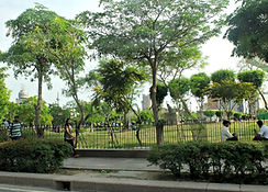
Earlier, the Inner Circle garden was a roundabout in the middle, but as time evolved, it turned into a park and road around it.
Things that work

Rich Street Life
Presence of Green Realm

Social Anchors

Commercial Exposure
Connaught Place – Existing Activities
This map shows how Connaught Place functions actively around food and retail clusters but unevenly elsewhere. The goal is simple: build on what’s lively and reconnect the inactive stretches to make the whole circle walkable and cohesive.

N
Legends

Retail
Food/ Beverage
Merchandise
Services
i
Existing Programming Diagram
Systematic re-design of Connaught Place

Phasing Diagram
Phase 1: Relocate Cars & Redefine the Movement
The first step shifts traffic to the outer ring, freeing inner streets for walking and cycling while keeping essential access by giving Connaught Place back to people.
Phase 2: Enhance & Improve Green & Public Realm
With traffic reduced, this phase adds greenery, shade, and native landscaping, making Connaught Place more walkable and inviting.
Phase 3: Creation of Urban Rooms
This phase creates “urban rooms” where plazas, shaded seating, and cultural pockets where people gather, with food carts and performances animating daily life.
Final Phase: Redefined & Improved Connaught Place
The final phase unites everything, Connaught Place reborn as a lively, people-centered core that balances heritage with modern life.
The New Connaught Place
The master plan redefines Connaught Place as a pedestrian-led public realm. Vehicular movement is redirected to the periphery, making space for shaded walkways, green pockets, and cultural nodes within the central park. Edges are lined with retail, art, and gathering zones, stitching together heritage, mobility, and daily urban life into one connected landscape.

Connaught Place Master Plan
Legend
Commercial Drop Zone
Existing Built Form
Transit Points
Transit Connection
Retail - Existing
Retail - New
Seating
Performance Spaces
Pavement
N

Designed Section
This section illustrates the layered experience from the street edge to the inner park. A pedestrian bridge hovers above drop-off lanes, leading into a series of transit entries framed by trees and public seating. Art walls and small retail units activate the edge, creating an interface that’s not just about movement, but about pause, engagement, and urban comfort.
Site #2 : Anand Vihar
Anand Vihar is one of Delhi’s busiest intermodal nodes—connecting metro, railway, ISBT, autos, and informal vendors in a chaotic tangle. While it plays a vital role in regional mobility, the site suffers from poor pedestrian access, unclear wayfinding, and underutilized public space. The following images capture its current realities and spatial pressures.


Shared Pedestrian zone
Bus Bays +ISBT Bus Entry

Informal market under
Metro Viaduct

Auto Depot Congestion

Flow Pattern Diagram
Legend
Commercial Drop Zone
Existing Built Form
Transit Points
Transit Connection
Retail - Existing
Retail - New
Seating
Performance Spaces
Pavement
N

Lack of Anchors on pedestrian bridge

Overflow traffic &
Drop-off Chaos

ISBT Chaos

Exploded Phasing Diagram
Phase 2: Establishing Commercial Anchor & Public Realm
This phase adds cafés, shops, and plazas to activate key routes and invite gathering.
Phase 1: Uplifting & Improving Pedestrian Movement
The first step prioritizes pedestrians with shaded paths, safer crossings, and clear routes linking transit to the street.
Phase 4: Enhancing Green Realm
Revived parks, buffers, and native planting cool the precinct and tie it together with a continuous green thread.
Phase 3: Improving Car Movement (Personal + Commercial)
Next, vehicle flow is streamlined with clear lanes for cars, buses, and services by reducing congestion while keeping streets pedestrian-first.
Final Result: A Redefined & Navigable Anand Vihar
Walkability, transit, commerce, and greenery come together to make Anand Vihar a legible, welcoming precinct—not just a transit hub.
Remastered Anand Vihar
The plan reimagines Anand Vihar as a layered transit hub balancing movement, ecology, and daily life. Clear pedestrian routes, separate traffic flows, shaded walkways, and green corridors connect transit nodes, while bazaars and stalls blend seamlessly into a more legible, comfortable public realm.

Legend
Commercial Drop Zone
Existing Built Form
Transit Points
Transit Connection
Retail - Existing
Retail - New
Seating
Performance Spaces
Pavement
N
Anand Vihar Master Plan

Designed Section
This sectional cut captures the full cross-section, from highway to public edge. It moves through informal markets nestled under metro viaducts, across tree-lined seating zones, and into shaded green spaces that run alongside the nala. Transit drop-offs, signage points, and retail pods are carefully placed to make movement intuitive. The section celebrates contrast: fast-moving infrastructure above, slow-paced public life below.
Addressing variability with Toolkit
Category - I
Formal + Colonial + Commercial
Series of Small Intervention
such as improved signage, lighting, active edges, and shaded pedestrian loops.
These are colonially planned and commercially active zones, like Connaught Place. Their structure is intact but aged, meaning interventions should be small, strategic, and layered. The focus here is on upgrading the public realm without disrupting the heritage or formal grid.
Category - II
Informal + Organic + Transit
Series of Big Intervention
including redesigned transit interfaces, consolidated pedestrian routes, and integrated green corridors
Areas like Anand Vihar fall under this type, which is chaotic but deeply embedded in daily movement. They evolve without clear planning, blending transit, markets, and improvised structures. These demand bolder, system-level interventions to reorganise flow and reclaim usable space.
Toolkit for Variable Elements

Food Court
A shaded eatery zone designed for casual gatherings, with modular seating integrated into a soft landscape. Its open frontage and tree canopy create a welcoming pause space along the public promenade.

Bridge
An elevated pedestrian link improves walkability across barriers, with ramps ensuring universal access. The bridge doubles as a scenic pause point, drawing foot traffic through layered connectivity.

Art Walk-in
A curated path winds through a gallery of outdoor art frames, turning walking into an immersive experience. Flanked by trees and pavilions, it blends play, culture, and creative interaction.

Urban Performance Area
An amphitheatre-style public zone that blends seating and stage, inviting spontaneous performance and leisure. It encourages informal gatherings, cultural events, and everyday relaxation under a canopy of trees.

Retail Island
A compact retail kiosk nestled within green trails, activating park edges without overwhelming nature. It supports local vendors and encourages slow movement through the landscape.

Urban Green Spoke
A meandering path weaves through shaded greens and playful street furniture, inviting passive recreation. Water features and seating nodes enhance ecological cooling and social comfort along the way.

Urban Bridge
A pedestrian bridge becomes a playful public space with seating, water features, and greenery. It shifts from being just a connector to a vibrant urban experience.

Urban Bazaar
A green spine integrates informal vending and shaded walkways to support local commerce. It invites community life to unfold in a walkable, human-scaled setting.

Urban Pause Points
Shaded kiosks, picnic tables, and trees create a cozy spot for people to rest, chat, or grab a bite. It blends leisure and light activity, turning everyday paths into meaningful pause moments.

Waiting Area - A
Intersecting paths, benches, and trees shape a relaxed waiting zone for everyday use. Soft landscaping and varied seating make it feel open, inclusive, and comfortable.

Waiting Area - B
This slender green strip offers a calm place to sit, wait, or stroll through leafy surroundings. Simple elements activate the edge while maintaining openness and flow.
Similar Elements


Modular Urban Seating
This series of modular urban seating designs integrates planters, shade, and flexible sitting surfaces to enrich the public realm. With clean forms and warm materials, they invite people of all ages to pause, relax, or interact—whether alone or in groups. Strategically placed near greenery or signage, these elements enhance walkability, comfort, and sociability in compact urban settings.
Categorized Pedestrianization Areas
The red heat map overlays areas with poor air quality, while white circles mark transit switching points. These overlap with many of the pedestrianization hotspots, reinforcing the urgency of walkable, breathable, and accessible urban public space.

2.1
2.2
2.3
2.4
1.3
1.2
1.1
1.4
Category - II
Informal + Organic + Transit
These lively, informal nodes grow organically around transit and daily commerce.
Category - I
Formal + Colonial + Commercial
These are historic grid-based zones with strong structure but underperforming edges.
Legends

Metro Line
Transit Switching Point
Poor AQI Area
Category - I
Category - II
N
Future Potential Sites